


Chilly weather driven by a polar air mass will continue to cause cold temperatures throughout the week.
Cold fronts crossing Australia’s southwest and southeast are expected to bring below-freezing conditions to several regions, with a widespread frost outbreak taking shape across the country.
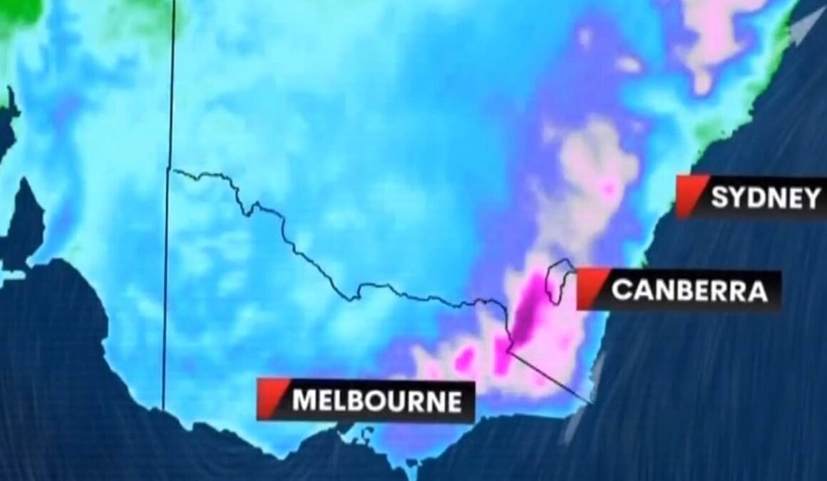
Weatherzone meteorologist Angus Konta said that conditions feel much colder than actual temperatures due to strong wind gusts in the southeast.
‘We have a cold air mass overhead and even though it’s quite sunny, it’s still relatively cold during the day because of the gusty winds and showers,’ he said.
‘In Melbourne, those showers should start to ease this afternoon, and it’ll start to feel much closer to the actual temperature.
‘In Sydney, we’re going to see those winds persist on the coast for the next couple of days, probably through Wednesday or Thursday.’
Light showers will persist along the east coast for the next few days.
Meanwhile, a cold front in southwest Western Australia will bring storms and showers, with the heaviest rain expected along the coastline south of Perth.
On Sunday, wintry conditions brought snow down to nearly 400m in the lower ACT, eastern elevated Victoria, and New South Wales‘ Central Tablelands. More snow is expected today.

Cold fronts crossing Australia’s south-west and south-east are expected to see conditions dip below freezing in several regions

Temperatures plunged on Monday morning across the country
Sydney
Monday: Mostly sunny morning. Cloud increasing in the afternoon with a medium chance of showers developing along the coastal fringe during the late afternoon and evening, slight chance elsewhere. Winds southwesterly 25 to 35 km/h. Max 16.
Tuesday: Partly cloudy. Medium chance of showers along the coastal fringe, slight chance elsewhere. Winds southwesterly 25 to 35 km/h. Min 8, Max 16.
Wednesday: Partly cloudy. Medium chance of showers along the coastal fringe, slight chance elsewhere. Winds south to southwesterly 20 to 30 km/h. Min 9, Max 17.
Melbourne
Monday: Cloudy. High chance of showers or drizzle, becoming less likely late this afternoon and evening. Light winds. Max 12.
Tuesday: Partly cloudy. The chance of fog in the morning, mainly about the nearby hills. Light winds. Min 7, Max 14.
Wednesday: Mostly sunny. Areas of morning frost. The chance of morning fog about the nearby hills. Light winds. Min 3, Max 13.
Brisbane
Monday: Sunny. The chance of frost in the south early this morning. Winds westerly 15 to 20 km/h turning southwesterly 25 to 35 km/h during the morning then decreasing to 20 to 30 km/h in the early afternoon. Max 21.
Tuesday: Sunny. Patches of morning frost in the west. Light winds becoming southerly 15 to 20 km/h in the morning then becoming light in the late afternoon. Min 6, Max 21.
Wednesday: Sunny. The chance of morning frost in the west. Light winds becoming southerly 15 to 20 km/h during the morning then becoming light during the evening. Min 7, Max 21.

Monday’s forecast was less snowy with dustings only expected above 700m following widespread flurries on Sunday

Perth
Monday: Partly cloudy. Medium chance of showers, most likely during this afternoon and evening. The chance of a thunderstorm about the northern suburbs during this afternoon and evening. Winds northwesterly 15 to 25 km/h. Max 20.
Tuesday: Partly cloudy. Very high chance of showers. The chance of a thunderstorm. Light winds becoming northwesterly 15 to 20 km/h in the middle of the day then becoming light in the late afternoon. Min 12, Max 21.
Wednesday: Cloudy. Very high chance of rain, most likely in the afternoon and evening. The chance of a thunderstorm. Heavy falls possible about the hills. Winds north to northeasterly 15 to 20 km/h turning west to northwesterly 25 to 35 km/h during the afternoon. Min 12, Max 22.
Adelaide
Monday: Mostly sunny. The chance of morning frost. Light winds becoming north to northeasterly 15 to 20 km/h in the morning then becoming light in the middle of the day. Max 15.
Tuesday: Mostly sunny. Light winds. Min 6, Max 16.
Wednesday: Partly cloudy. Light winds. Min 7, Max 17.
Hobart
Monday: Partly cloudy. Patches of frost this morning, mainly in the north. Light winds. Max 11.
Tuesday: Partly cloudy. Light winds. Min 3, Max 13.
Wednesday: Partly cloudy. The chance of morning fog in the east. Light winds. Min 5, Max 13.
Canberra
Monday: Mostly sunny. Patches of morning frost. Light winds becoming southerly 15 to 20 km/h in the morning then becoming light in the late afternoon. Max 11.
Tuesday: Partly cloudy. Areas of morning frost. Light winds. Min -4, Max 12.
Wednesday: Partly cloudy. Areas of morning frost. Light winds. Min -3, Max 13.

The cold front over the east is expected to continue driving chilly temperatures before a secondary front moves over from the west from Friday
Darwin
Monday: Mostly sunny. Winds southeasterly 20 to 30 km/h tending easterly in the morning then becoming light in the late afternoon. Max 32.
Tuesday: Partly cloudy morning, sunny day. Light winds becoming easterly 20 to 30 km/h in the morning then becoming light in the evening. Min 22, Max 32.
Wednesday: Mostly sunny. Winds southeasterly 25 to 35 km/h tending easterly during the morning then becoming light during the afternoon. Min 23, Max 33.