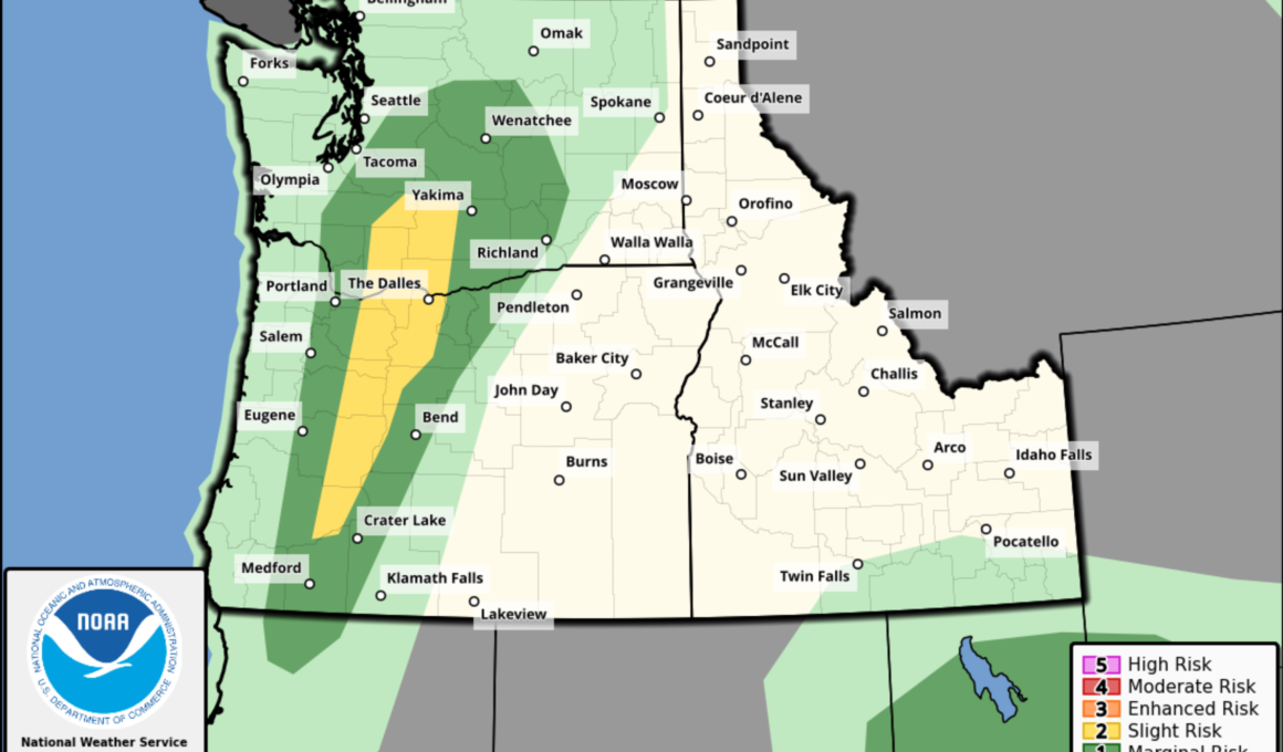
Two states are at risk for a “rare regional outbreak of severe thunderstorms” this weekend, according to a weather outlook map from the National Weather Service (NWS) Storm Prediction Center.
NWS meteorologists are forecasting a slight risk, the second of five severity levels issued by the organization, for severe weather in a long band from southern Washington south through central Oregon on Saturday. There’s a much wider risk area for a “marginal risk” of severe weather, and nearly the entirety of Washington, the western half of Oregon and northern California are forecast to endure thunderstorms.
“A rare regional outbreak of severe thunderstorms, with multiple supercells bringing large hail and damaging winds, will be possible tomorrow across Oregon and Washington. Closely monitoring for a potential storm chase,” extreme storm chaser Colin McCarthy posted on X, formerly Twitter, with the map.
More From Newsweek Vault: 5 Steps to Build an Emergency Fund Today
A rare regional outbreak of severe thunderstorms, with multiple supercells bringing large hail and damaging winds, will be possible tomorrow across Oregon and Washington.
Closely monitoring for a potential storm chase. pic.twitter.com/xj4c9SR3Zr
— Colin McCarthy (@US_Stormwatch) August 16, 2024
In the forecast, the NWS warned that “scattered to numerous late-afternoon and evening thunderstorms should be focused from south to north across the Cascade Range” on Saturday. The setup could allow for supercells that are “capable of both severe hail and wind.“
“The wind threat may be relatively greater across parts of the Columbia Valley near the OR/WA border area as storms cluster into the early evening,” the forecast said.
More From Newsweek Vault: What Is an Emergency Fund?
NWS meteorologist Samantha Borth told Newsweek that the storms will be “more widespread than usual,” prompting a closer look from local meteorologists. Typically, Borth said, storms in the Seattle area are more isolated this time of year. She said wind, heavy rain and lightning will be the biggest concerns.
The severe weather comes as the Pacific Northwest has battled wildfires, prompting NWS meteorologists to issue an advance flash flood watch for several areas within the forecast region given the prevalence of burn scars.
More From Newsweek Vault: Compare the Best Banks for Emergency Funds
One such alert was issued for south central Washington, including the areas around the Washington Cascades. The flash flood watch is in place for Saturday afternoon through late Saturday night.
“Heavy rainfall could trigger flash flooding of low-lying areas, urbanized street flooding, and debris flows in and near recent wildfire burn scars,” the alert said. “National Weather Service Meteorologists are forecasting heavy rainfall from thunderstorms over the burn scars along the east slopes of the WA Cascades, which may lead to flash flooding and debris flows.”
Similar flash flood watches were issued for the Seattle, Washington, and Portland, Oregon, areas.
“Heavy rainfall is expected over the 2024 burn areas associated with active wildfires. Residents near these areas should prepare for potential flooding impacts. Be sure to stay up to date with information from local authorities,” the NWS office in Portland warned. “Heavy rainfall could trigger flash flooding of low-lying areas, and debris flows in and near recent wildfire burn scars.”


