CNN
—
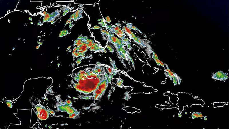
Tropical Depression Four has strengthened into Tropical Storm Debby in the southeastern Gulf of Mexico, according to the National Hurricane Center.
Debby has sustained winds of 40 mph and is located about 70 miles northwest of Havana, Cuba, according to the hurricane center’s 5 p.m. ET update on the storm.
The latest forecast calls for the storm to intensify into a Category 1 hurricane with 75 mph winds just before landfall Monday morning in Florida’s Big Bend region.
Hurricane warnings are now in effect for the Florida Gulf Coast from the Suwannee River to the Ochlockonee River, including the entire Big Bend Region.
A hurricane watch was issued earlier Saturday, from Yankeetown, above Crystal River, northward and around the Big Bend region to Indian Pass on the Florida Panhandle.
Track the Storm: Spaghetti models and more maps here
The Big Bend area is still recovering from a devastating blow by Category 3 Hurricane Idalia last August as it prepares for a new threat from Debby.
Other alerts warning of tropical storm conditions over the next 48 hours span the entire western Florida coast south of the Big Bend and include Tampa, Sarasota, Fort Myers and Naples. A storm surge warning stretches from Aripeka, about 45 miles northwest of Tampa, up to the mouth of the Aucilla River.
A tropical storm warning remained in effect for the Florida Keys from the Seven Mile Bridge westward, according to the hurricane center’s 5 p.m. ET update.
The hurricane center said the storm system became better organized by late Saturday morning as it moved toward Florida and landfall. “Heavy rainfall will likely result in locally considerable flash and urban flooding across portions of Florida and the coastal areas of the Southeast this weekend through Thursday morning.”
“Hurricane conditions are possible in the hurricane watch area by Sunday night, with tropical storm conditions expected to begin on Sunday,” the hurricane center said. “Tropical storm conditions are expected to spread northward over the tropical storm warning areas this evening and continuing through Sunday.”
“Very Intense” rainfall is expected in southwest Florida on Saturday and a widespread 3 to 5 inches of rain could fall, according to the Weather Prediction Center. The intense rain will be potent enough to cause flash flooding, even in marshy areas of the state more capable of handling excess water.
The storm is forecast to continue to strengthen through the weekend and up to landfall while tracking through the Gulf of Mexico parallel to the western coast of Florida.
“This is a life-threatening situation. Persons located within these areas should take all necessary actions to protect life and property from rising water and the potential for other dangerous conditions,” the hurricane center said. “Promptly follow evacuation and other instructions from local officials.”
Cedar Key was slammed by Idalia in 2023; the storm surge then was 8 to 12 feet in Big Bend.
Shifts in the storm’s exact track and strength are still possible over the next 48 hours, but a key factor in the increasing chances for a hurricane is how much time the system spends over record-warm water in the eastern Gulf of Mexico.
Sea surface temperatures in the Gulf of Mexico are approaching records, currently in the middle to upper 80s. Some water temperatures are even approaching the lower 90s off the coast of Tampa Bay. Warm water is fuel for storms to strengthen and potentially rapidly intensify, a phenomenon becoming more likely as global temperatures rise because of fossil fuel pollution.
Forecasters shifted the storm’s track to the west and believe the storm will spend more time over water now.
“The westward shift to the track forecast now also keeps the system over the warm waters of the Gulf of Mexico longer, giving the system additional time to potentially strengthen,” the hurricane center said. “It is important to note that because of the forecast track being parallel to the west coast of Florida, the location and timing of a potential landfall cannot be pinned down at this time.”

Where and when the storm comes ashore and how strong it is at that time will affect the risk of “life-threatening” storm surge.
Up to 5 feet of storm surge is possible in parts of the Big Bend and up to 4 feet is possible from Bonita Beach north through Tampa Bay.
No matter its strength, torrential, flooding rain will be the most significant impact from the storm, especially with the system forecast to slow down after landfall.
Storm could stall over the Southeast
After landfall Monday, the storm is forecast to track to the northeast over portions of northern Florida and southern Georgia.
But the atmospheric components that help steer and push storms along are forecast to breakdown and cause future-Debby to slow significantly while over the Southeast early next week.
The flood threat increases dramatically with slower storms, as they linger over the same areas and dump repeated bouts of heavy rain. Five to 10 inches of rain – potentially more – is forecast over coastal portions of Georgia, South Carolina and North Carolina.
As a result, the risk of flooding rainfall was increased to a level 3 of 4 over the coasts of Georgia and South Carolina, including Savannah and Charleston, for Monday into Tuesday.
It’s also possible that this risk level will increase to a level 4 of 4 depending on the future track of the storm, the Weather Prediction Center said.
Freshwater flooding – flooding caused by rainfall – has become the deadliest aspect of tropical systems in the last decade, according to research conducted by the National Hurricane Center.
A world warming due to fossil fuel pollution is making this potential threat more dangerous. Studies also have shown tropical systems are slowing down over time, which means they’re more likely to produce greater rainfall totals over a given area.
Oceans are also getting warmer and supercharging storms, pumping them full of moisture. A 2022 study published in the journal Nature Communications found climate change increased hourly rainfall rates in tropical storms by 5 to 10% and in hurricanes by 8 to 11%.
Florida prepares for deluge
Florida Gov. Ron DeSantis has declared a state of emergency for 54 of the state’s 67 counties to mobilize resources as the storm churned toward the Sunshine State.
“Floridians are encouraged to monitor weather conditions, listen to all orders from local officials, create disaster preparedness plans, and stock disaster supply kits with food, water, and other necessities for their households,” the governor’s office said Friday.
Local governments have started putting out advisories. Citrus and Levy counties have issued mandatory evacuation orders in certain low-lying areas and for some residents living in manufactured homes or RVs. Voluntary evacuation notices have been announced in other areas of both counties, along with Pasco and Taylor Counties.
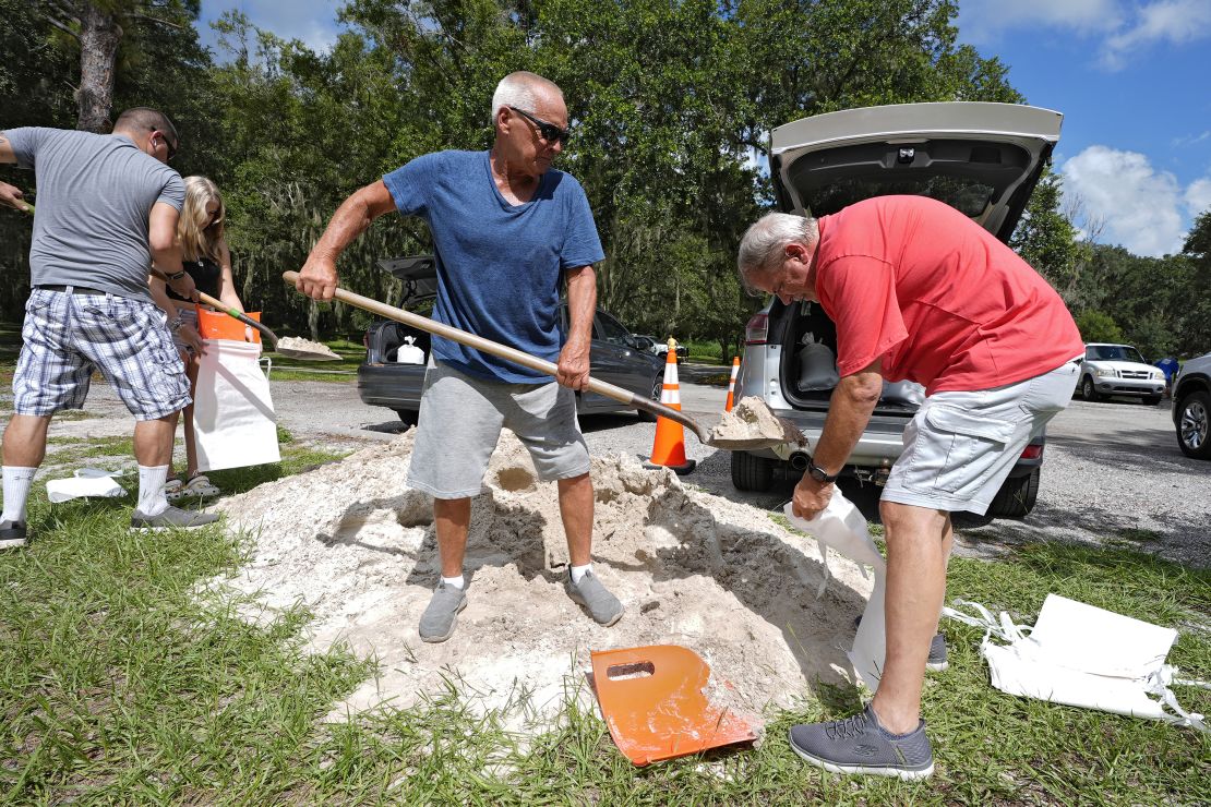
Sandbag distribution began Friday for residents in several communities in the Orlando and Tampa metros. Multiple counties in the state’s panhandle – including Escambia, Okaloosa and Santa Rosa – started distributing sandbags Thursday.
“You still have some time to put your disaster supply kit together,” Hurricane Center Director Michael Brennan said. “Make sure you have multiple days of food, water, prescription medicines. Keep your gas tank full, cash on hand, and keep batteries. Make sure your phone’s charged and make sure you have a battery powered radio.”
Georgia Gov. Brian Kemp also declared a state of emergency Saturday ahead of Debby’s possible impacts.
“As the state prepares for a major storm system early this coming week, we urge all Georgians to take precautions to keep their families and property safe. I’ve issued a State of Emergency through Thursday, August 8,” Kemp said in a post on X.
CNN’s Taylor Ward, Allison Chinchar, Elliana Hebert, Elisa Raffa, Sarah Dewberry, Raja Razek, Paradise Afshar and Joe Sutton contributed to this report.


